Saturday, May 2nd, 2026
BIKES OUT OF HIBERNATION/PEDAL THE PARKWAY
Williamsburg, VA - April 2026 - Bikes out of Hibernation (BooH), taking place May 2nd this year, is an annual WAB event, co-sponsored by James City County Parks & Rec, Jamestown Settlement, and BikeWalk Williamsburg. The purpose of BooH is to encourage residents of the community to dust off their bikes and get them ready for the cycling season. The event will take place at the Jamestown Settlement parking lot from 9am to 1pm. Representatives from several local bike shops will provide free safety checks and minor adjustments. Afterwards, participants are encouraged to ride on the Virginia Capital Trail, Jamestown Island, or the Colonial Parkway. The national park service will also sponsor the "Pedal the Parkway" the same day, permitting riding and walking on the parkway free of vehicles that same morning from the Jamestown Settlement to the Kingspoint Drive exit, approximately.
Other Rides to Make it a Weekend!
If you are traveling to Williamsburg to ride this year, why not make it a cycling weekend? There are many great cycling opportunities in Williamsburg for both on- and off-road cycling. Here are six options to help make it a weekend!

Incorporate Pedal the Parkway into a longer Saturday ride.
If you start at Jamestown Settlement and ride the Colonial Parkway to Williamsburg and back, you can then connect to the Virginia Capital Trail and ride to Chickahominy Riverfront Park and back for a 31-mile car-free ride. Refreshments may be purchased at Spoke & Art on the Virginia Capital Trail on the way to Chickahominy Riverfront Park. At the end of the ride, you can purchase food and drink at Billsburg Brewery across the street from Jamestown Settlement. Here is the map and cue sheet for the “Pedal the Parkway – Virginia Capital Trail Loop”, or you can use RideWithGPS.
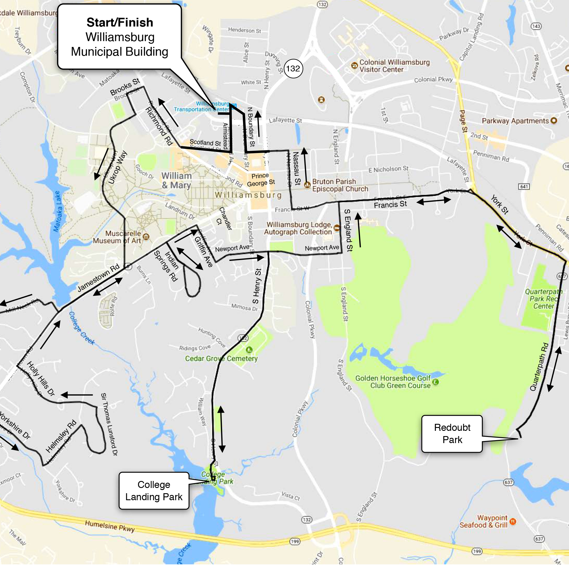
Williamsburg Explorer – 15 miles.
This route starts at the Williamsburg Municipal Building, 401 Lafayette Street, Williamsburg, VA) and takes you through some of the City’s old and new residential neighborhoods, the College of William & Mary, and visits two City parks. College Landing Park was one of the two colonial ports for Williamsburg, and Redoubt Park was the location of Redoubt #1 of Williamsburg’s Civil War defensive line. Here is the map and cue sheet for this ride, or you can use RideWithGPS.

Jamestown/Winery Loop – 25 miles
This route starts at the Williamsburg Municipal Building (401 Lafayette Street, Williamsburg, VA) and takes you from Williamsburg to Jamestown Island for the seven-mile Jamestown Island loop. Jamestown Island is a National Park Service fee area, and you can purchase a ticket at the Jamestown Island Visitor Center. From Jamestown Island, you take the Colonial Parkway back towards town, and exit the Parkway on a connector trail to Treasure Island Road, which goes past the Williamsburg Winery where you can have lunch at the Gabriel Archer Tavern. Here is the map and cue sheet for this ride, or you can use RideWithGPS.

Yorktown Battlefield Loop – 12 miles
This route starts at the Yorktown Battlefield Visitor Center (1000 Colonial Parkway, Yorktown, VA) and traverses Yorktown’s Revolutionary War battlefield. The Yorktown Battlefield is a National Park Service fee area, and you can purchase a ticket at the Yorktown Battlefield Visitor Center. If you do this ride, we recommend viewing the exhibits at the Visitor Center first, and then riding the Battlefield roads. For lunch, there are six restaurants along the Yorktown waterfront. Here is the map and cue sheet for this ride, or you can use RideWithGPS.

Yorktown + Battlefield – 37 miles
NOTE: THIS ROUTE IS NOT AVAILABLE PRESENTLY DUE TO CONSTRUCTION ON THE COLONIAL PARKWAY BETWEEN WILLIAMSBURG AND YORKTOWN. This route starts at the Williamsburg Municipal Building (401 Lafayette Street, Williamsburg, VA) and takes you from Williamsburg to Yorktown along the Colonial Parkway (which is not closed to traffic), adds the Yorktown Battlefield roads, and has an optional lunch stop at on the Yorktown waterfront before riding back to Williamsburg. The Yorktown Battlefield roads are a National Park Service fee area, and you can purchase a ticket at the Yorktown Battlefield Visitor Center. Here is the map and cue sheet for this ride, or you can use RideWithGPS.

Chippokes-Surry Loop – 23 miles
This route starts at the Jamestown Settlement Parking Lot (2110 Jamestown Rd, Williamsburg, VA). You ride your bike onto the Jamestown-Scotland Ferry and exit the Ferry in Surry County across the James River. The nice thing about taking the Ferry is that all the cars leave first, so there is no one behind you when you leave. From the Ferry you ride back roads to Chippokes Plantation State Park where you can take a rest stop at the Visitor Center and visit the Farm and Forestry Museum. From the Park, you ride through the town of Surry and then back to the Ferry. Before you reach the Ferry, you can stop for lunch at the Surry Seafood Company (633 Marina Dr, Surry, VA). Here is the map and cue sheet for this ride, or you can use RideWithGPS.
Our 2019 Sponsors
We would like to Thank our 2019 BikeWalk Williamsburg Sponsors who support the mission to foster a bicycling and pedestrian friendly Greater Williamsburg, through community outreach with programs like Pedal the Parkway, Cycling Without Age, bicycle rodeos, helmet fittings, give aways, and the installation of bike Fixit stations.
If you would like to add your name to the list, please contact us! info@bikewalkwilliamsburg.org